Monday, October 20, 2008

Ecstasy of the King of Forts :Raigad Fort

Route: Pune -> Paud-> Mulshi -> Tamhini -> Vile Phata (Take Left Turn from here) -> Nizampur -> Mangaon -> Mahad -> Raigad (Total 164km one way)

Total distance covered:323 km
Date of Travel: 20th Sep 2008 (Saturday)

Places Visited:

Raigad Fort : Raigad is a hill fortress situated in the modern day Raigad district of Maharashtra, India. The Maratha king Shivaji made the fort his capital in 1674 when he was crowned king of a Marathi kingdom which later developed into the Maratha Empire.

The fort, which rises 820 metres (2,700 ft) above sea level, is located in the Sahyadri mountain range. There are approximately 1400–1450 steps leading to the fort, though today a rope-way exists to reach the top of the fort.

Shivaji Maharaj had seized the site, then the fortress of Rairi, from the royal house of the Chandarrao Mores, a junior or Cadet dynasty descended from the ancient Maurya imperial dynasty. The last More king (or raja) was a feudatory of the Sultan of Bijapur.

Shivaji renovated and expanded the Fortress of Rairi and renamed it Raigad (the King's Fort), the name he gave it when he selected it for his capital when he was in the process of assuming the royal character. Rajgad, a hill fortress situated in Raigad District of Maharashtra, India was capital of Shivaji's kingdom.


Now the story begins :


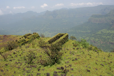
(View From Fort)


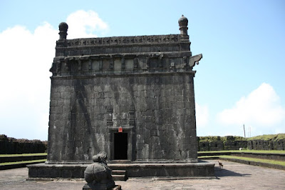
(Nagarkhana Darwaja)


Saturday, September 20, 2008

Sunday, August 3, 2008

Walk in the Clouds : Shivthargal

Route: Pune -> Bangalore Highway NH4 (Take right turn at a petrol pump next to Nasrapur) -> Bhor - > Varandha Ghat(120 km from Pune) - > Shivthargal (another 18 km)

Total distance covered: 280km
Date of Travel: 2nd Aug 2008 (Saturday)

Places Visited:

Bhor Ghat

Varandha Ghat( in Raigad District. Ancient forts are visible in the ghat. From the top one can have commanding views of Rajgad and Torna.

To the left peak of the ghat lies Kawla Fort, located at an elevation of about 2,000 ft. The Shivthar Ghal, famous for caves, is at the foothills. )

Shivthargal (Shivthar is a small village located in Sahyadri footsteps and adjoining Kawlya fort and Madhe ghat region.It is a calm and quiet place good for peace and meditation.It also has lots of waterfalls in rainy season SunderMath was built by Ramdas swami in Shivthar and later it was properly built in year 1860 and behind that just 100 metres is the famous cave where Dasbodh was written.)

Now the story begins :

(Map to Shivthargal via Bhor ghat and Varandha Ghat)


Way to Bhor Ghat


Colors of Monsoon


A stunning view from Warandha Ghat


Picture Perfect

Saturday, June 21, 2008

On the Trail Of Bhimashankar

Route: Pune -> Nashik Highway NH50 (Take right turn at Nashik Phata) -> Chakan-> Rajgurunagar -> Manchar - > Bhimashankar

Total distance covered: 256km
Date of Travel: 21th Jun 2008 (Saturday)

Places Visited:

Bhimashankar Temple
Bhimashankar Wild Life Sanctuary


Monday, June 9, 2008

Amidst Pouring Rains : Malshej Ghat

Route: Pune -> Nashik Highway NH50 (Take right turn at Nashik Phata) -> Narayangaon - > Ojur - > Shivneri - > Malshej Ghat (NH 212)


Total distance covered: 259km (Including Ojur and Shivneri)
Date of Travel: 08th Jun 2008 (Sunday)

Places Visited:

Asthavinayak - Ojur (Shri Vigneshwar)

Shivneri Fort (Birthplace of Shivaji)

Malshej Ghat (region comprises the stretch of the Sahyadris from Harishchandragad in the north to Bhimashankar in the south).


(Map: Pune -> Malshej Ghat)


(Small temple at Malshej Ghat)


(Majestic View from Malshej Ghat)

(Another Stunning View - Obviously not from Google Map)